Arctic Heatwave — February 2 Temperature +13 F Above Normal
Reblogged from: RobertScribbler.Wordpress.com.
Heat just keeps flooding into the Arctic. And as late winter progresses to early spring, this inexorable influx of warmth may have profound impacts to both world weather and to the eventual state of sea ice by the end of summer 2014.
After a record warmth event shattered all time high temperatures across Alaska and resulted in melt-spurred avalanches that cut off Valdez from the mainland, heat in the high Arctic continued to intensify through late Sunday. According to reports from The Climate Change Institute, the Arctic temperature anomaly hit +7.07 C (nearly +13 F) above daily averages for the entire Arctic on February 2.
By Monday, this exceptional Arctic heat spike had faded somewhat, dropping to a still extreme +6.14 C (+11 F) above the, already warmer than normal, 1979 t0 2000 average.
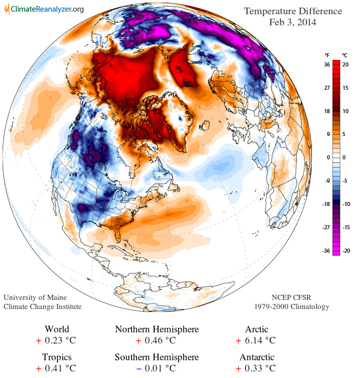
(Daily temperature anomaly from the Climate Change Institute. Data compiled from NASA and NOAA global monitors, satellite data and model analysis.)
Note the extraordinarily hot readings of +36 F over a large area of the Beaufort and Chukchi Seas coinciding with almost as extreme instances of warmth along the west coast of Greenland and throughout a region over Svalbard stretching on toward Arctic Russia.
Current temperatures in Svalbard mirror those in Gaithersburg, Maryland, thousands of miles to the south, with both sitting at 32 degrees F according to reports from Weather Underground. Svalbard is less than 600 miles from the North Pole and temperatures there are currently pushing the freezing mark, a level not typically breached in Svalbard until May.
Arctic sea ice near all-time lows
The exceptional Arctic heat has kept both sea ice extent and area near all time lows this winter with NSIDC showing extent and areas measures at their 3rd lowest for this date. Sea ice area anomaly is now 1.014 million square kilometers below the already low 1979 to 2008 mean, a significant negative deviation for winter.
As a result, some areas that are usually frozen solid by this time of year show little or no ice. The Bering Sea, for example, remains about 3/4ths open ocean. This is an extraordinary event as the Bering ice pack is usually approaching the Aleutians by this time of year. But, as we can see in the map below, huge patches of open water for this and other areas remain.

(Snow and ice extent for February 3, 2014. Note that the ice edge is far behind the 1979 to 2000 average limit line in all basins. Image source: Climate Change Institute.)
With the end of the freeze season about 30 days away, it would take a significant switch to cold to make up for the current ice lag. Meanwhile, Jet Stream models show the pace of heat influx to Arctic regions remaining high at least through the end of this week. Notably, a strong, warm-core high pressure system is predicted to develop in the region of the Bering Strait by Friday. This developing zone is projected to drive yet one more flood of warmth almost all the way to the North Pole:

(Jet Stream model predictions for Friday, February 7th show warm core high pressure system over extreme eastern Russia and Bering Strait. Image source: The University of Washington.)
In this pattern, the polar vortexes remain disassociated from the Arctic, with one being centered over Siberia and the other finding an almost permanent residence near Hudson Bay. It is also worth noting that this Jet Stream forecast also indicates a high likelihood of severe weather for the eastern US by February 7th as well.
Arctic heat likely to continue to shove cold air, instability extreme weather south
Though the polar vortex collapse related Arctic air invasion of the US last week has now mostly faded, as noted above, Jet Stream models indicate continued major Arctic air outflows from the much hotter than usual Arctic into Canada and the US. This continued instability sets the stage for a major battle between hot and cold air as regions southward warm up in anticipation of the advance of spring. The result is likely to bring numerous episodes of severe weather outbursts throughout the month of February. So we cannot rule out strong to extreme rain/snow events, thunderstorms, flooding and potential tornadoes as February progresses. As has been typical with the current Jet Stream pattern, the Central and Eastern US are most likely to be effected by these strong storm events. And, as we have seen with the increasingly severe climate-change driven extreme weather events of the past decade, the potential continues for record or near-record events.
Shifting west, a set of weaknesses in the high amplitude blocking pattern is likely to allow a stream of moisture to filter in over the parched western states. Unfortunately, this rain will probably arrive too little, too late to prevent major troubles for states like California come spring. In short, it would take a major inundation to alleviate drought conditions for the moisture-starved west. And a weakened, but still sputtering, blocking pattern isn’t likely to deliver the kind of moisture needed to end California’s 13 year drought. That said, any relief is likely a welcome change to those living through the worst conditions in at least 4 decades.
No Great Lakes freeze for 2014
In parting, I’ll leave you with a clear sign that, while the heat in the Arctic is plainly historic, the cold it drove into the US this winter was merely a noteworthy after-effect. The Great Lakes which, prior to the mid 20th Century, used to freeze solid almost every year, despite the recent cold snaps, remain ice free over a broad area.
The last year all the Great Lakes froze solid? 1979…

(Great Lakes with substantial portion still ice-free. Image source: Lance-Modis)
Links:
Arctic Heatwave Sets off Hottest Ever Winter Time Temperatures for Alaska
Forgive me for posting so much on this subject, but this is really scary stuff.

Sure, we’ll make up the guest room. It’s been cool here (highs around 50 F, lows around 20 F), but no snow. A little snow wouldn’t hurt; our drought has gone on for over two months. You know, they say adversity builds character. :-).
LikeLike
Lake Michigan is an arms reach of me. We’re at 69% ice coverage. All we’re hearing up here is how the barges can’t get thru it. The other odd thing with so much more ice than normal is that we don’t get the lake effect snow we are used to. Ice stops the evaporation of h2o, so less snow. Ahhh, I just wish we’d get a blast of snow. I can get to work in -15F… I can’t in 15 inches of snow! ! Can I come visit? I’m about over this white stuff 😂
LikeLike